Tittle
August heat map arriving across the UK
Uk august heatwave weather map
Summer is at its strongest in August this year and many people are looking ahead for signs of a heatwave official forecasts from the Met Office suggest that dry and warmer conditions will develop particularly from mid August across southern and eastern parts of England toward Wales naturally Scotland Northern Ireland may remain more unsettled early in the month
The first half of August between the second and eleventh may feel changeable cooler air will linger across Northern Ireland western Scotland and parts of the northwest with a mix of showers and variable temperatures low to mid twenties Celsius in contrast regions in the southeast will begin to see warmer spells briefly touching thirty degrees Celsius or more
As we move into the period from around August twelfth to twenty sixth high pressure is predicted to build more steadily over the UK creating more persistent dry settled conditions in the south and east warmer temperatures will become far more frequent occasionally topping thirty two or even thirty three Celsius in central eastern England and Wales
What that means for the heat map
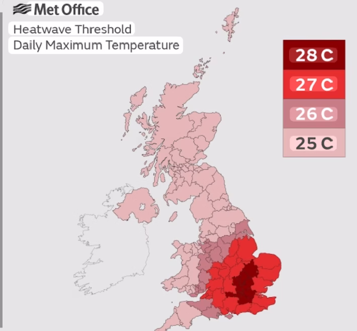
The map above highlights areas most at risk of heatwave levels later in August the deepest reds correspond to places where a sequence of three consecutive days over regional thresholds may be reached these are most likely in southeast England and central belt Wales while Scotland may see isolated warm days still unlikely to meet heatwave criteria earlier in the month
Heatwave temperature thresholds vary by area in northern and western UK the threshold sits near twenty five degrees Celsius while in southeastern counties including Greater London thresholds reach up to twenty eight Celsius that means sustained warmth above those levels for several days would qualify as an official heatwave
Why conditions favour heat spells
Background climate conditions are supportive of rising summer extremes coastal and inland sea surface temperatures are elevated with warm air being drawn from continental Europe several days in a row of sunshine and high pressure over the Azores will steer warmer air into the UK making lasting August heat more likely than usual
The Met Office three month outlook indicates that summer months are now over two times more likely to be hotter than normal compared to the average for 1991 to 2020 record breaking temperatures from earlier this season and climate science both suggest multiple short hot spells may still occur in the coming weeks
What to expect in practical terms
Expect heat to arrive in stages warmer days may first appear in the southeast by late August and spread north and west if the high pressure dominates expect occasional peaks into the low thirties with overnight temperatures staying elevated
The heat will be intermittent rather than one long stretch but enough intensity to trigger health warnings especially where minimum overnight temperatures remain above twenty Celsius and pollen and UV levels spikehttps://manyviral.com/can-trumps-big-beautiful-bill-pass-the-senate/
You might to like read this blog
Leave a Reply